
Community Event:
Members of the public who are unable to join the online meeting, can attend an in-person public meeting on Monday, November 17, beginning at 6:00 PM at the Coatesville Moose Lodge at 1200 Airport Road, Coatesville, PA 19320.
All information below courtesy of PennDOT.
King of Prussia, PA – The Pennsylvania Department of Transportation (PennDOT) invites the public to attend a live virtual public meeting on Thursday, November 13, and an in-person open house plans display on Monday, November 17, to review the revised improvement alternatives for the U.S. 30 Bypass and Route 10 Intersection Reconstruction Project in Sadsbury and West Sadsbury townships, Chester County.
This project is one of a series of projects that will upgrade a 4.3-mile section of the U.S. 30 (Coatesville-Downingtown Bypass) corridor to improve safety, reduce congestion, accommodate planned growth, and improve system connectivity.
As part of PennDOT’s project outreach, the department encourages the public to attend the live virtual public meeting on Thursday, November 13, beginning at 6:00 PM, by clicking on this Microsoft Live Teams meeting link prior to the presentation start time. The department’s design team will deliver a project presentation before opening the meeting to questions using the platform’s Q&A feature.
Please note that internet access or a computer or mobile device are required to view the virtual meeting. Anyone with special needs or requiring special aid is requested to contact PennDOT Project Manager Steven Fellin at 610-205-6821 or PennDOT Consultant Design Public Outreach Coordinator Nicole Kline at 610-594-9995.
Members of the public who are unable to join the online meeting, can attend an in-person public meeting on Monday, November 17, beginning at 6:00 PM at the Coatesville Moose Lodge at 1200 Airport Road, Coatesville, PA 19320.
The meeting will be conducted as an open house where citizens will have the opportunity to circulate among the subject displays to gather information and discuss the different facets of the project with PennDOT’s design team.
For more on this project, and PennDOT’s U.S. 30 Reconstruction Program, visit www.us30-chesco.com.
Below are verbatim excerpts of PennDOT public material from: https://us30-chesco.com/project-information/western-section/pa-10-interchange-area-2/ where you can find more information.
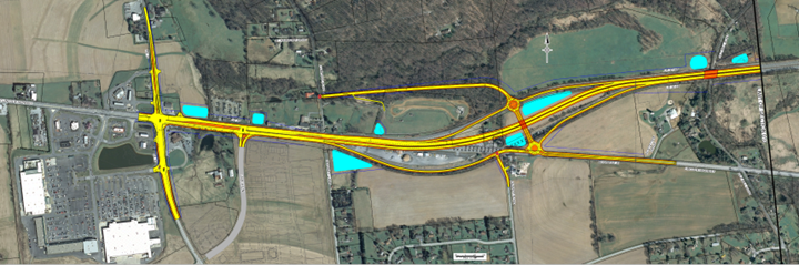
EXISTING CONDITIONS
The existing interchange of US 30 and Business US 30 provides both eastbound and westbound on-ramps and off-ramps. The existing intersection of US 30 and PA Route 10 is an at-grade, signalized intersection.

- The existing Western Terminus provides an eastbound on-ramp and connection to eastbound Business US 30.
- The existing Western Terminus provides a westbound off-ramp and connection from westbound Business US 30.
- The existing intersection of US 30 and PA Route 10 is signalized.
PURPOSE AND NEEDS
Purpose
The purpose of the project is to provide a safe and efficient transportation system by improving safety, reducing future congestion, accommodating planned growth, and improving facility deficiencies.
Needs
The project needs have been identified: Safety, Facility Deficiencies, and Congestion/Anticipated Growth
- Safety – Several locations within the project corridor have crash rates that exceed the statewide average for the same type of facility. Peak travel time congestion, narrow or absence of shoulders, and inadequate signalization and traffic signal phasing contribute to the high crash rates.
- Facility Deficiencies – Substandard roadway conditions exist throughout the project corridor. The existing pavement within the project area is approaching the end of its useful service life. The outer (right) shoulders are narrow and deteriorated. Two structures currently have insufficient vertical clearance.
- Congestion/Anticipated Growth – The existing traffic at the signalized intersection of US 30 and PA 10 currently exceeds the capacity during certain periods of the day, which results in congestion and driver delay. In the future, growth is anticipated to continue along US 30 and PA 10 in the area, resulting in higher vehicular traffic volumes and further congestion and delay.
ENVIRONMENTAL RESOURCES
Some of the significant environmental features of the project area include farmland, a church, a nature preserve, township open space, historic properties, six streams, and 12 wetlands. A total of 15 active agricultural parcels are present, one of which is in the Sadsbury Township Agricultural Security Area. The Gateway Grace Community Church is located south of US 30. The Sadsbury Woods Preserve owned by the Natural Lands Trust is located to the north of US 30. Sadsbury Township open space used for recreation abuts the preserve. There are two historic properties along the highway west of the US 30/Business US 30 merge. Buck Run is the main stream present and, along with its five tributaries, supports natural trout reproduction. Two of the wetlands present are open-water farm ponds. The remaining 10 wetlands support predominately emergent vegetation and are considered to of exceptional value due to their connection with the Buck Run streams.
US 30 MAINLINE
The existing typical section and the proposed typical section for US 30 mainline is illustrated in the graphic below. The proposed typical section has not changed from the previous public outreach.

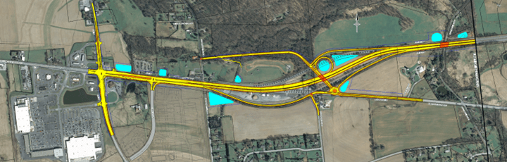
REVISED PROJECT ALTERNATIVES
As a result of further evaluation, it was determined that a new set of revised alternatives to include a full-movement grade-separated interchange between US 30 and Business US 30 would better achieve the purpose and needs as opposed to the previously evaluated set of alternatives.
REVISED ALTERNATIVE R1 OVERVIEW
REVISED ALTERNATIVE R1 INTERCHANGE AREA

- A new grade-separated diamond interchange is provided for US 30 and Business US 30.
- A new roadway connection is provided from the new interchange to Compass Road, and the existing intersection of Compass Road at US 30 is eliminated.
- Two single-lane roundabouts are provided at the new interchange ramp terminal intersections.
- Three variations are under consideration at Quaker Road (same for R1 and R2).
REVISED ALTERNATIVE R2 OVERVIEW
REVISED ALTERNATIVE R2 INTERCHANGE AREA
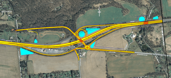
- A new grade-separated interchange is provided for US 30 and Business US 30.
- A new roadway connection is provided from the new interchange to Compass Road, and the existing intersection of Compass Road at US 30 is eliminated.
- The westbound ramps are modified to include a loop road, and the westbound ramp terminal intersection is stop-controlled.
- One single-lane roundabout is provided at the new interchange for the eastbound ramp terminal intersection, which is the same design as Alternative R1.
- Three variations are under consideration at Quaker Road (same for R1 and R2).
QUAKER ROAD ALTERNATIVES
Three variations are under consideration at Quaker Road (same for R1 and R2), as follows:
- Alternative 01: Business US 30 and Quaker Road stop-controlled T-intersection remains, with some realignment.
- Alternative 02: Quaker Road is realigned to tie into the interchange roundabout.
- Alternative 03: The Quaker Road intersection at Business US 30 is eliminated.

DECISION MATRICES


NOISE IMPACT
The Western Terminus/Route 10 Project Area (Section 10) is currently in the Conceptual Design phase, which will take approximately one year to complete. The next phase will be Preliminary Engineering and Environmental Evaluation, which is anticipated to last approximately two to four years. Final Design will follow, with a two-to-four-year timeframe.
The following graphic illustrates the steps within the noise evaluation process. The use of noise barriers will be evaluated during the Preliminary Engineering and Environmental Evaluation phase. Additional public meetings and special process meetings will be held as the project progresses to discuss the possible use of noise barriers.
NOISE EVALUATION PROCESS

RIGHT OF WAY INFORMATION
Since the Western Terminus/Route 10 Project Area (Section 10) is currently in the Conceptual Design phase, property impacts are not yet known. Should your property be needed for transportation purposes, you will be contacted, and you may be assured that PennDOT’s Right-of-Way Representatives will gladly answer any questions you may have. You may also be assured that it is PennDOT’s intention to achieve the best possible transportation facilities while maintaining your satisfaction as a private landowner. More information about the acquisition process can be found in PennDOT Publication 83.


 LanChester NUZ 92.9 provides links to web sites of other organizations in order to provide visitors with certain information.