

Read Time:1 Minute, 6 Second
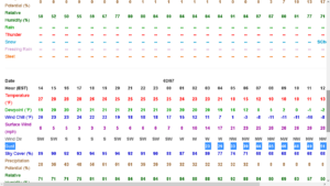
421 AM EST Tue Mar 3 2026

...WINTER WEATHER ADVISORY REMAINS IN EFFECT UNTIL 1 PM EST THIS
AFTERNOON...

* WHAT...Mixed precipitation expected. Total ice accumulations up to
  one tenth of an inch. Snow and sleet accumulations less than one
  inch.

* WHERE...A portion of central Pennsylvania.

* WHEN...Until 1 PM EST this afternoon.

* IMPACTS...Plan on slippery road conditions. The hazardous
  conditions will impact the Tuesday morning commute.

* ADDITIONAL DETAILS...Freezing rain will change to rain by early
  this afternoon.

PRECAUTIONARY/PREPAREDNESS ACTIONS...

The Pennsylvania Department of Transportation and Pennsylvania
Turnpike Commission remind motorist to adjust speeds based on
driving conditions as winter weather impacts Pennsylvania roadways.
Visit www.511pa.com for the latest travel, roadways, and traffic
conditions.
201 AM EST Mon Mar 2 2026

...WINTER WEATHER ADVISORY IN EFFECT FROM 4 AM TO 1 PM EST TUESDAY...

* WHAT...Mixed precipitation expected. Total ice accumulations up to
  one tenth of an inch and snow accumulations less than one inch.

* WHERE...A portion of central Pennsylvania.

* WHEN...From 4 AM to 1 PM EST Tuesday.

* IMPACTS...Plan on slippery road conditions. The hazardous
  conditions could impact the Tuesday morning commute.

* ADDITIONAL DETAILS...A light glaze of ice is expected late tonight
  and Tuesday morning, especially on the higher elevations.

PRECAUTIONARY/PREPAREDNESS ACTIONS...

Slow down and use caution while traveling.

Happy
0 %
Sad
0 %
Excited
0 %
Sleepy
0 %
Angry
0 %
Surprise
0 %
 LanChester NUZ 92.9 provides links to web sites of other organizations in order to provide visitors with certain information.