
NWS Weather Prediction Center College Park MD
358 PM EDT Thu Jun 02 2022 Valid 00Z Fri Jun 03 2022 – 00Z Sun Jun 05 2022
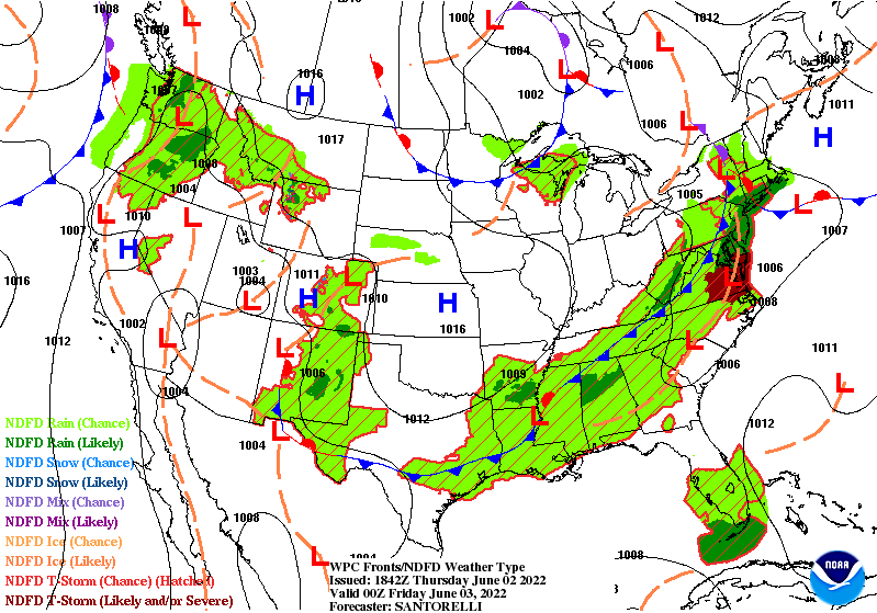
…Showers and thunderstorms to impact the southern and eastern U.S. today with cooler temperatures arriving to end the week… …Severe weather will be possible across portions of the Mid-Atlantic states today… …A tropical disturbance in the Gulf of Mexico to bring very heavy rainfall and flooding to parts of Florida… A very warm, moist, and unstable airmass along and ahead of a cold front moving through the southern and eastern portions of the country will continue to focus numerous showers and thunderstorms this evening and overnight from the southern Plains and lower Mississippi Valley northeastward across the Mid-Atlantic states and portions of New England. Storms along this boundary will be capable of strong to severe weather and locally heavy to excessive rainfall. The best chance for severe weather though will be across parts of the Mid-Atlantic this evening, as per the latest update from the Storm Prediction Center. Rainfall should move off the East Coast by Friday, but linger across the Southeast into the weekend as the boundary stalls. Behind the front, cooler and drier air will be arriving from the Midwest and this will sweep across the Ohio and Tennessee Valleys, and through most of the Mid-Atlantic and portions of the Northeast. A tropical low, with high likelihood of becoming a tropical cyclone in the next day or two, will cross into the southeast Gulf of Mexico on Friday. Heavy rainfall and gusty winds will begin affecting south Florida and the Florida Keys on Friday and continue into the weekend, with rainfall totals of 4 to 8 inches, locally up to 12 inches, possible. Considerable flash and urban flooding is possible, especially across the more sensitive urban corridor of southeast Florida. Please refer to the latest from the National Hurricane Center. Out West, a weak Pacific storm system impacting the Pacific Northwest will bring some scattered showers and thunderstorms through Friday. The moisture and energy with this system will stretch downstream across areas of the northern Rockies and out into the northern Plains and Upper Midwest going into the early part of the weekend as well. Scattered areas of showers and thunderstorms are also expected farther south across the central and southern Plains as southerly flow returns and moisture begins surging back north with temperatures quickly warming through the weekend especially across the southern High Plains/west Texas.


 LanChester NUZ 92.9 provides links to web sites of other organizations in order to provide visitors with certain information.